.png)

Upcoming Projects
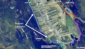
Larose Ted Gisclair Lock
Conversion of the Larose Ted Gisclair Floodgate into a Lock Complex. This project will allow continued traffic down Bayou Lafourche when water levels are too high to leave the system open.
Status: Designed & Permitted. Awaiting Funding
Engineer: Picciola & Associates, Inc.
Cost Estimate: $40 million
Funding Sources:
SLLD Funds: $5 million
CPRA Funds: $20 million
Lafourche Parish Government: $15 million (awaiting award of FEMA Hazard Mitigation Grant Program Funds through Lafourche Parish)

Section A-West Levee Improvements
Elevation to +19.5' of Section A-West - the southwestern most portion of the overall levee system. Current levee is at approx. +16' in elevation.
Status: In Final Design
Engineer: Angelette Design
Cost Estimate: $5.7 million
Funding Sources:
CPRA Funds: $4.5 million
SLLD Funds: $1.2 million

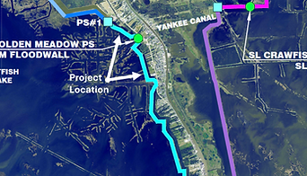
A-East Bayou Water Retention
To control the water levels in Bayou Lafourche, SLLD siphons water near Yankee Canal in Golden Meadow and pumps it out of the system at Pump Station #4. A nearby +600 acre open water area makes it difficult and time consuming to draw the bayou down. A retention levee with water control structures is currently being designed to help SLLD hold the water in this area, so the bayou levels can be managed more efficiently.
Status: In Final Design
Engineer: GIS Engineering, LLC
Cost Estimate: $1.465 million
Funding Sources:
TBD

Section E-North - NW Corner to NE Corner
Elevation to +14.0' of Section E-North from the Northwest corner of Clovelly Farms to the Northeast corner. Current levee is at approx. +11' in elevation.
Status: Preliminary Design
Engineer: GIS Engineering
Cost Estimate: $3.1 million

B-North & South Levee Improvements
Elevation to +18.0' of approximately 7.25 miles of levee between the Ronald Callais Pump Station and Pump Station #2 on the west side of the system. Current elevations vary between +15.0' and +17.0'
Status: Preliminary Design
Engineer: Angelette Design
Cost Estimate: $19.7 million
Section A-East Levee Improvements
Elevation to +19.5' of Section A-East - the southeastern most portion of the overall levee system. Current levee is at approx. +16' in elevation.
Status: In Final Design
Engineer: Picciola & Associates, Inc.
Cost Estimate: $7 million
Funding Sources:
CPRA Funds: $7 million

Levee Recertification
After Hurricane Katrina in 2005, the US Army Corps of Engineers (USACE) created a new set of hurricane storm damage risk reduction design guidelines stemming from the failures of the levee system around the city of New Orleans. These guidelines have caused the cost of levee construction to increase astronomically. Given the proven success of levees in the South Lafourche area, the SLLD has continued to design and construct levees according to sound engineering principles that have proven themselves effective--most significantly during Hurricane Ida in 2021. In 2011 the SLLD levee system lost its USACE certification and accreditation and was removed from the Rehabilitation and Inspection Program (RIP) that funds repairs to levee systems after natural disasters. The SLLD is currently working with the USACE to prove the effectiveness of our existing levees and be reinstated into the RIP.

Section A-West Levee Improvements - Callais Pump Station to Apache Dock
Elevation to +18.0' of Section A-West from the Ronald Callais Pump Station to the Apache Dock. Current levee is at approx. +16' in elevation.
Status: Preliminary Design
Engineer: GIS Engineering
Cost Estimate: $1.9 million
D-North Levee Improvements
Elevation to +16.0' of approximately 4.8 miles of levee providing direct protection to LOOP's Clovelly facility and the Greater Lafourche Port Commission Leonard J. Miller, Jr. Airport. Current elevations vary between +12.5' and +15.5'
Status: Preliminary Design
Engineer: Picciola & Associates
Cost Estimate: $11.3 million